| Allegheny Township, Somerset County, Pa. | |
| Note: You can see the detail in these maps better by zooming in. Hold down the Ctrl key and repeatedly press the + (plus) key, or roll the mouse wheel forward to zoom in. To zoom back out, hold down the Ctrl key and repeatedly press the - (minus) key, or draw back on the mouse wheel. | |
|
|
|
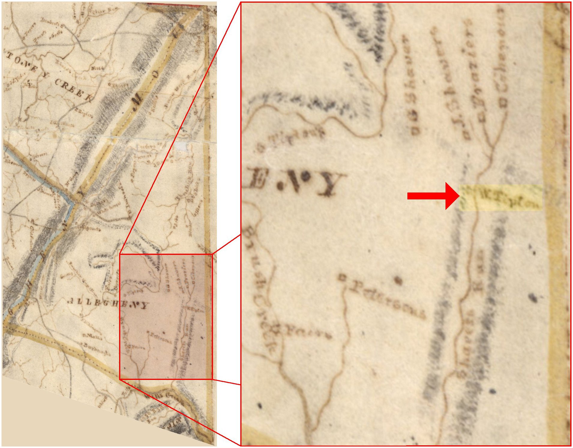
1818 Whiteside Map of Allegheny Township, Somerset Co., Pa., with the section shaded in the left map shown enlarged on the right. This map shows where W. (William) Tipton lived on the west side of Shaffer's Run (the dot representing the location of his home is barely visible). The wooded hillside on this west side of the stream is still called Tipton's Woods by local residents. Note: This map was digitally distorted somewhat (overall, not internally) to align the township boundary with that of later maps. |
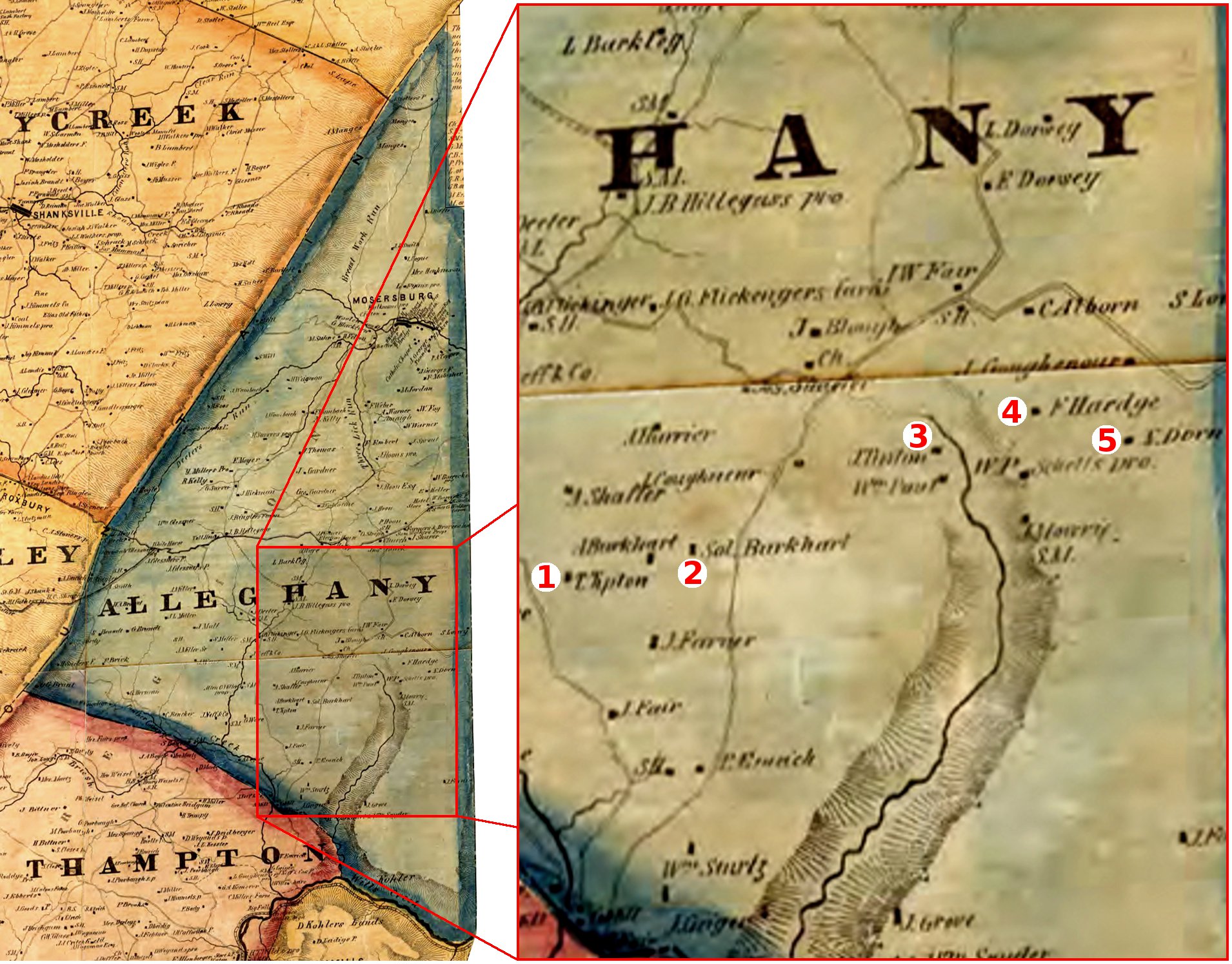
1860 Walker Map of Allegheny Township. The Walker Map of Somerset County was published on nine pages, or tiles. Parts of four tiles were digitally combined to create this map of Allegheny Township. The shaded area in the left map is shown enlarged on the right, and corresponds to the same area enlarged for the 1818 Whiteside map. Some residents shown are 1 - Thomas Tipton, 2 - Solomon Burkhart, 3 - Jacob Tipton, 4 - Frederick Hartge (at the Hartge homestead), and 5 - Nicholas Dorn. |
|
According to the History of the Tipton Clan
by Noah Tipton, when Noah was about six years old, Jacob Tipton moved from "the old place" (the original homestead) down to
"where the buildings now stand", which would be Jacob's location on the east side of Sheaffer's Run
as shown on the 1876 Beers Atlas map below left (where the barn foundation and well, pictued further down on this page,
are located today). Noah was born in 1844, so that dates Jacob's move to about 1850.
However, the 1860 Walker Map above right appears to show Jacob on the west side of the stream, ten years after he supposedly moved.
Jacob's location on the 1860 map seems to be at
about the same location where his grandfather William lived as shown on the 1818 Whiteside map, above left.
The best explanation for the ten year discrepancy is that some of the information on the Walker Map was probably outdated by
ten years or longer by the time the map was published. Keep in mind that this was in 1860, and there was a lot of information that
was brought together to create the Walker map for all of Somerset County before it could be published. |
|
|
|
|
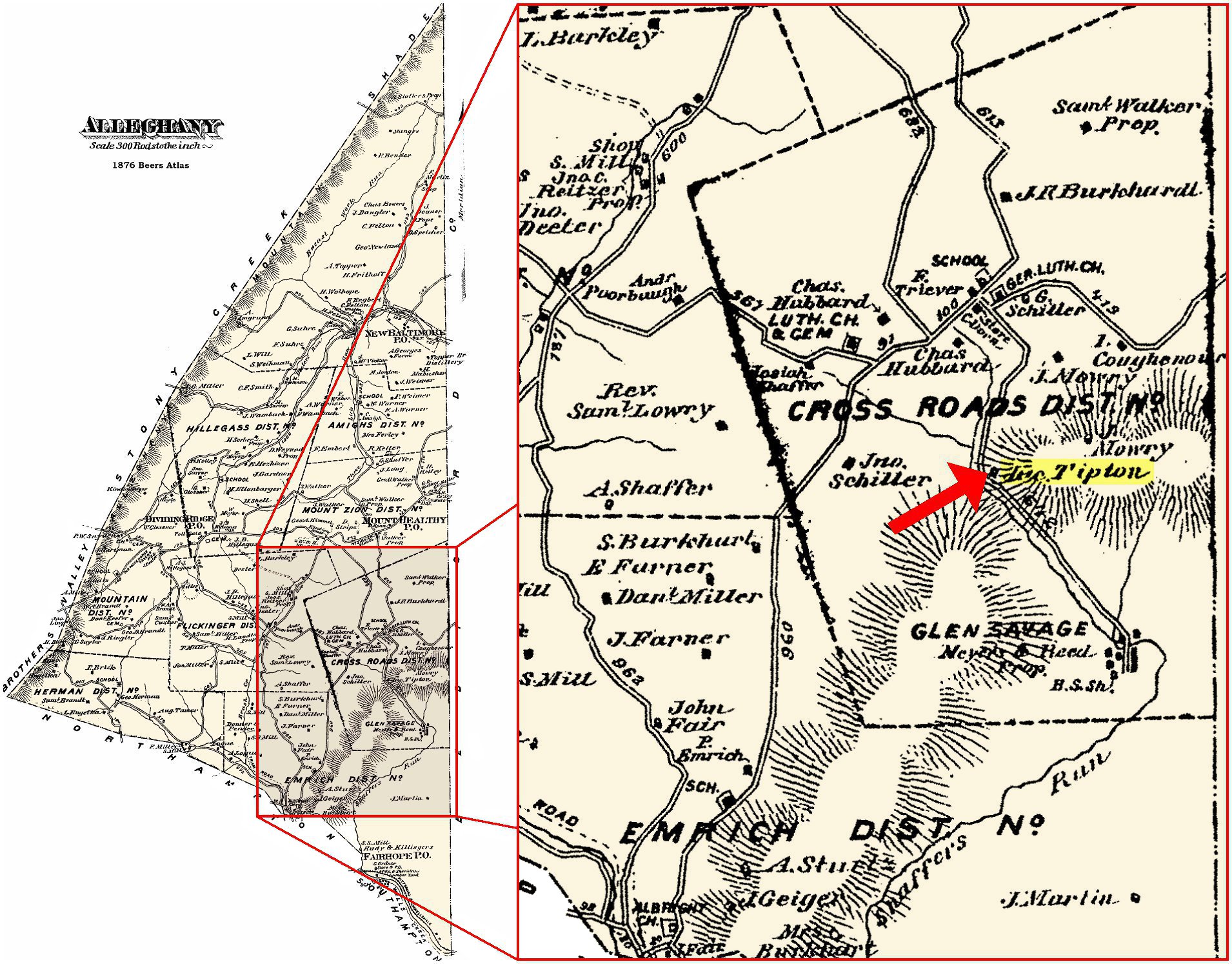
1876 Beers Atlas map of Allegheny Twp., Somerset Co., Pa., with the section shaded in the left map enlarged on the right. This map shows Jac. (Jacob) Tipton living on the east side of Shaffer's Run inside a bend in the road (now Shaffer's Run Road). The barn foundation and well pictured below are at this location. Note: This map has the cluster of buildings southeast of Jacob's place mislabeled as the village of Glen Savage, which is in fact the cluster of buildings directly north of Jacob's place. |
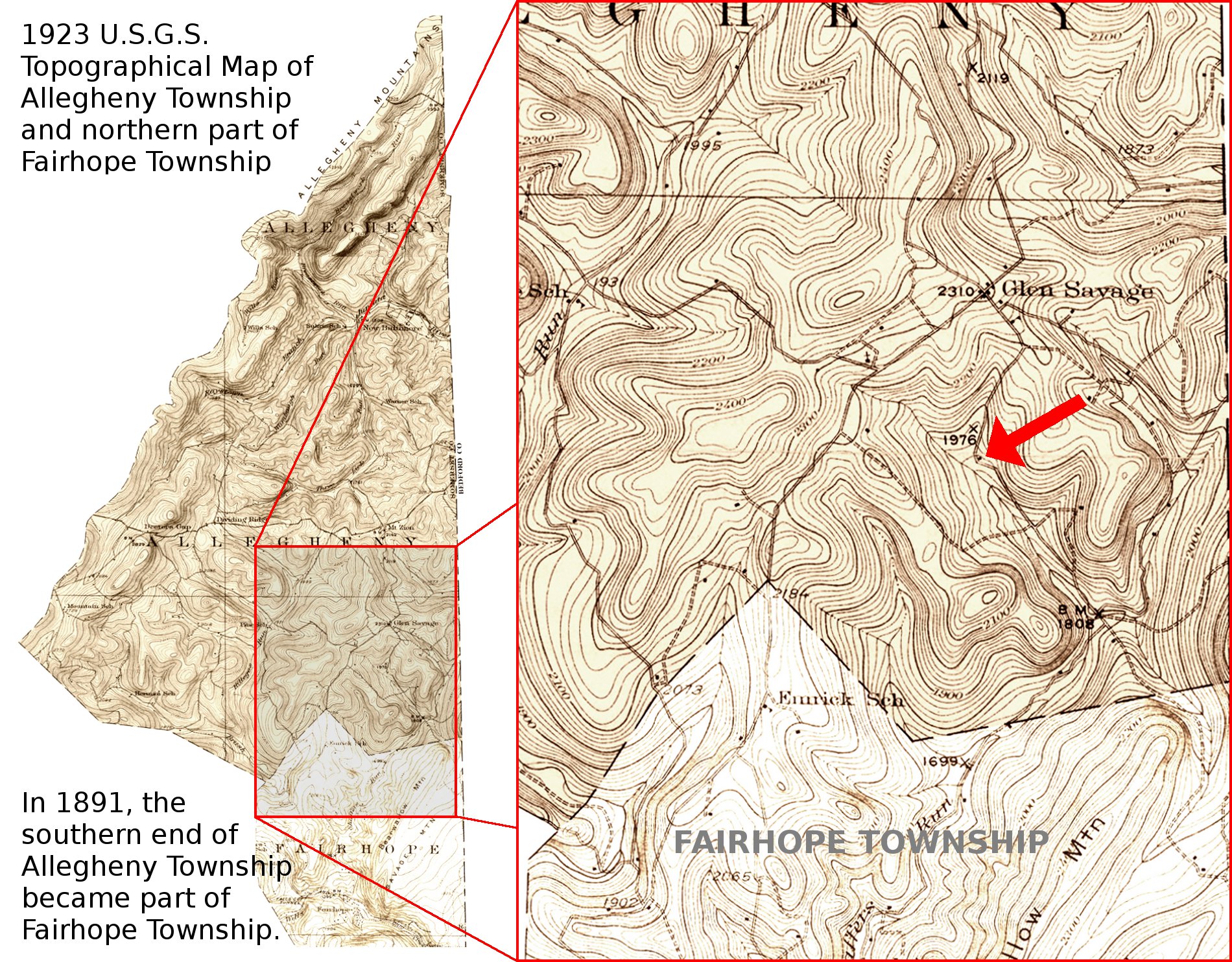
1923 U.S.G.S. Topographical Map of Allegheny Township and part of Fairhope Township with the shaded section on the left enlarged on the right. This map shows the Jacob Tipton house is still standing at this time (red arrow), 20 years after Jacob died. The house is gone now, and no evidence of it remains in the meadow where it stood. |
|
|
|
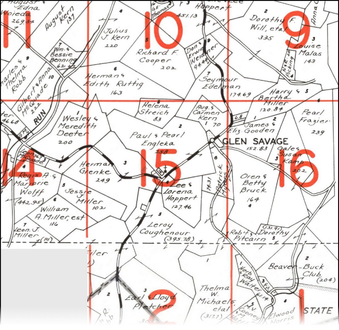
1968 Landowner Map. The section of Allegheny Township shown
corresponds to the enlarged map sections above, except that the bottom of this map is cut off (the missing area
is not significant). The tract of land at the heart of Tipton's Woods was owned by Lee &
Lorene Hoppert. It is immediately below and to the right of the number
15.
Lorene is a great-granddaughter of Jacob Tipton. This tract was the last in this
area to be in the Tipton family (it was sold around 2000).
Jacob's place was at the bend in the road immediately east of the bottom tip of the Hoppert tract. |
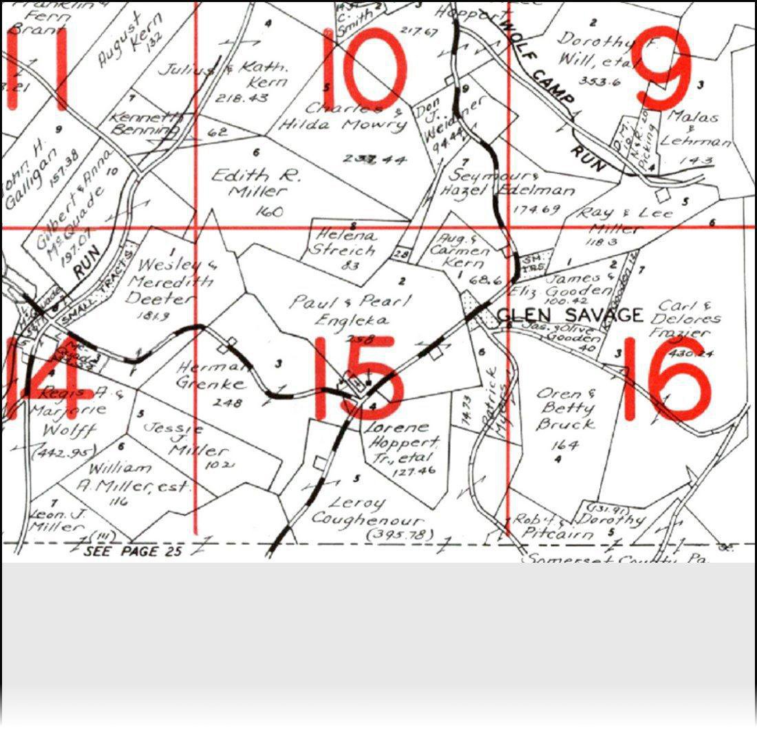
1980 Landowner Map, same section of Allegheny Township as the 1968 map to the left, again with the bottom left uncompleted. Jacob Tipton's land is owned at that time by Leroy Coughenour (as it was in 1968). This property is presently (2011) owned by cousins Gregory Coughenour, Brian Coughenour, and Cheryl Glessner. The Coughenours were early settlers of this area and one (spelled Cohenour) was a neighbor of William as shown on the Whiteside Map above. That map also shows a neighbor named Frazier, and a considerable tract of land east of Glen Savage is shown as still being in the Frazier family. |
| Terrain Map showing some relevant places... | |
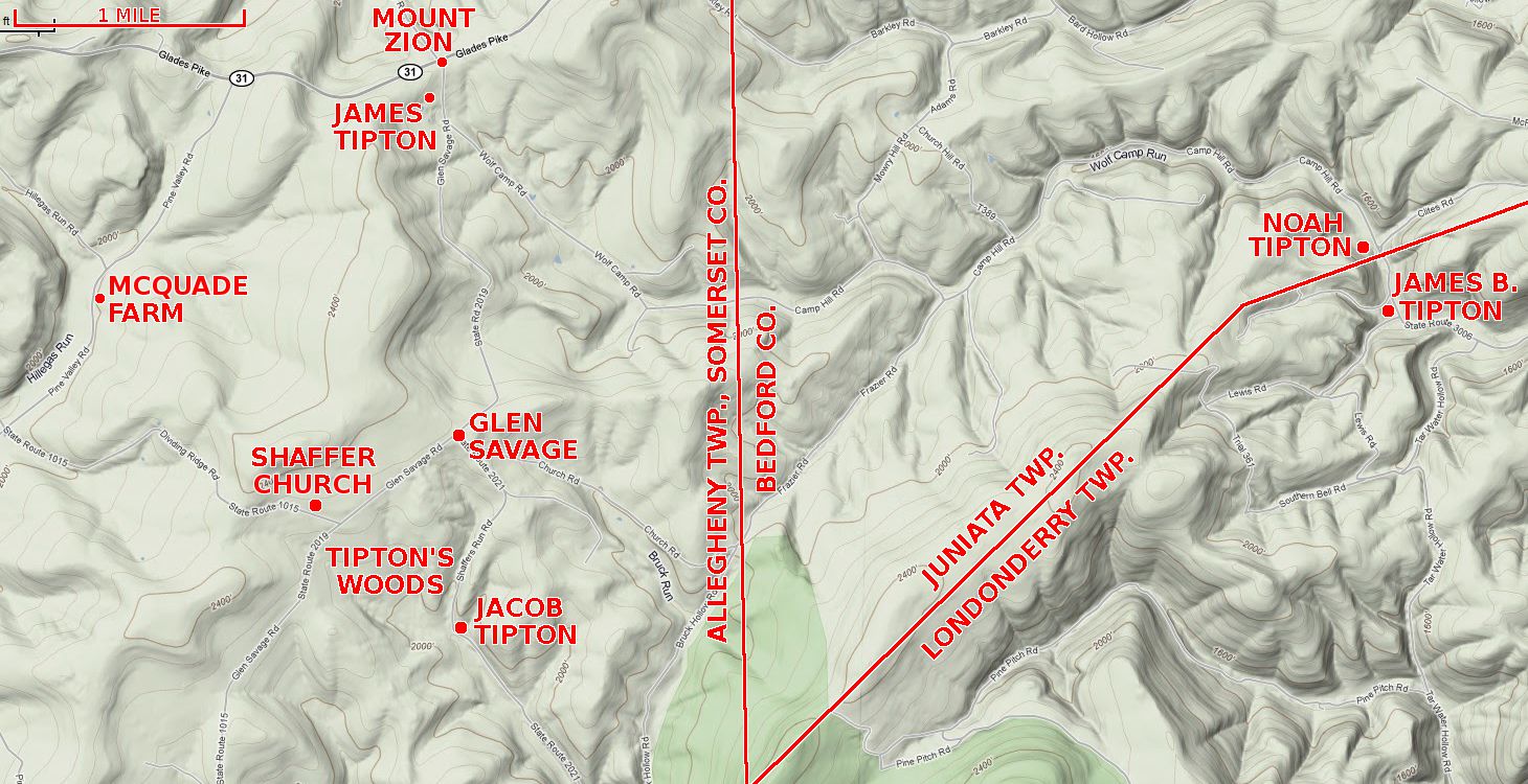 Terrain map courtesy of Google Maps
|
|
|
MOUNT ZION
Crossroads on Rt. 31, location of Mount Zion Lutheran Church and Cemetery,
where several Tiptons are buried. GLEN SAVAGE Small village a few miles south of Mt. Zion, only a few occupied homes remain. SHAFFER CHURCH Also known as the Mt. Olive Church, Jacob and Lucinda (Coughenour) Tipton and children Ann Lovina, Samuel, and William are buried here. Location of the Tipton Reunions 1921-1922, 1924-1927, 1929-1942. TIPTON'S WOODS Wooded hillside south of Glen Savage, the original Tipton homestead is believed to be somewhere in these woods. |
JAMES TIPTON
Home and farm of James Tipton, son of Jacob and Lucinda. JACOB TIPTON Home and farm of Jacob Tipton from 1850 until about 1890. Location of the well and barn foundation pictured below. NOAH TIPTON Home and farm of Noah Tipton, Jacob's father, before Noah and wife Elizabeth (nee Wagaman) moved to Illinois about 1864. JAMES B. TIPTON Home of James B. Tipton, Noah's son and Jacob's younger brother, before James and family moved to Illinois about 1864, then a few years later they moved to Kansas. |
|
MCQUADE FARM
Home and farm of John C. Reitz from about 1868 until sometime between 1880 and 1900.
John ran a steam-powered sawmill and a door and sash factory (which no longer exist) across the road from the farmhouse.
The cluster of buildings can be seen near the top left corner of the enlarged section of the
1876 Beers Atlas map shown above (John's name is shown as "Jno. C. Reitzer"). In 1878, John's daughter Emma Jane married
John Wesley Tipton, son of Jacob and Lucinda, and John and Emma took over the farm a few years later when John Reitz moved his lumber
business to Black Twp. Living next to John and Emma were
John's brother-in-law and sister, George Ellis and Anna R. (Tipton) Lafferty, with whom John and Anna's father Jacob lived
his final years. In 1904, John Tipton moved his family over the White Horse Mountain
to the town of Berlin, and after his daughter Binnie married John Edward McQuade, Binnie and John took over the farm.
Beginning in 1947, the Tipton Reunions were held here for many years, as the farm was known at that time as the John Tipton farm.
The property is still in the McQuade family. |
|
| Jacob Tipton Farm, Glen Savage (today) | |||
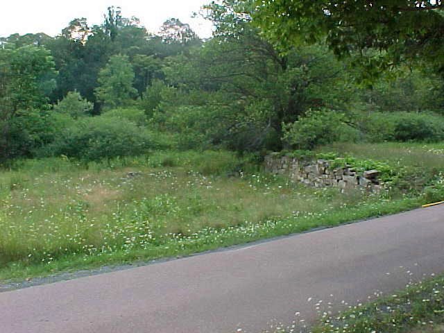
Foundation of the old Jacob Tipton bank barn along Shaffer Run Road near Glen Savage, Allegheny Twp., Somerset Co., Pa. The north wall against the dirt bank (right side) is the only significant portion remaining, although the whole foundation can be traced by following stones that formed the base of the other walls. |

Old Jacob Tipton well (boarded over) along Shaffer Run Road near Glen Savage, across the road from the barn foundation. There is nothing remaining of the house that stood in the meadow next to the well. |
||
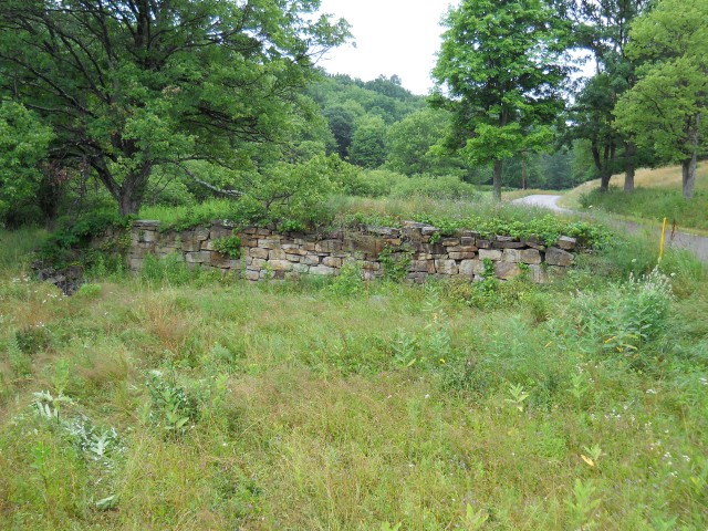
Better view of the north wall
of jacob Tipton's bank barn. The barn was in the foreground. |
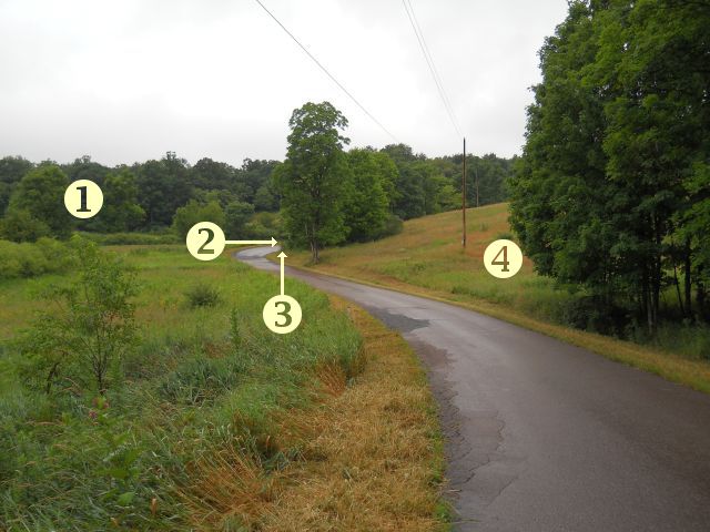
View looking north along Shaffers Run Road, south of Glen Savage. Key: 1 - Tipton's Woods, 2 - Jacob's bank barn, 3 - Jacob's well, 4 - meadow (partially hidden by trees) where the house stood |
||
| Send a message to the site manager |